Comprehensive Guide to Analyzing Flood Risks and Drainage Systems in InfraWorks
Introduction: Flooding poses a significant threat to communities and infrastructure worldwide, with devastating consequences for property, livelihoods, and public safety. Analyzing flood risks and designing effective drainage systems are crucial steps in mitigating these risks and ensuring the resilience of infrastructure projects. Autodesk InfraWorks provides powerful tools and capabilities that enable engineers, planners, and designers to analyze flood risks, simulate drainage systems, and develop strategies for flood management. This comprehensive guide aims to provide a detailed overview of how to analyze flood risks and drainage systems in InfraWorks, offering step-by-step insights and expert tips to master this critical aspect of infrastructure development.
Understanding Flood Risks and Drainage Systems: Before delving into the specifics of flood risk analysis and drainage system design, it’s essential to understand the fundamentals of these concepts. Flood risk analysis involves assessing the likelihood and potential consequences of flooding in a given area, considering factors such as rainfall patterns, topography, land use, and infrastructure vulnerabilities. Drainage systems are designed to manage stormwater runoff and mitigate flooding by collecting, conveying, and storing excess water during heavy rainfall events, preventing damage to property and infrastructure.
Key Features of InfraWorks: InfraWorks offers a range of features designed to streamline the analysis of flood risks and drainage systems, including:
- Terrain Modeling: InfraWorks provides intuitive tools for creating detailed 3D models of terrain, enabling engineers to analyze flood inundation and drainage patterns accurately.
- Hydrology and Hydraulics: The software includes hydrology and hydraulics analysis tools that allow users to simulate rainfall runoff, flood inundation, and drainage system performance under various scenarios.
- Geospatial Data Integration: InfraWorks integrates geospatial data, such as aerial imagery, LiDAR data, and GIS layers, enabling engineers to analyze flood risks and drainage systems in the context of the surrounding environment.
- Visualization and Reporting: InfraWorks offers realistic rendering capabilities that allow users to visualize flood inundation, drainage networks, and flood risk zones in high fidelity. Additionally, the software provides reporting tools for documenting analysis results and communicating findings to stakeholders.
Analyzing Flood Risks in InfraWorks: The process of analyzing flood risks in InfraWorks involves several key steps, from collecting data to simulating flood events and evaluating potential impacts. Here’s a comprehensive guide to analyzing flood risks in InfraWorks:
- Collect Data:
- Gather relevant data sources for flood risk analysis, including rainfall data, topographic maps, land use data, and hydrological information.
- Import geospatial data into InfraWorks, including terrain models, aerial imagery, and GIS layers, to provide context for the analysis.
- Define Design Storms:
- Define design storms based on historical rainfall data, regional climate patterns, and design standards for flood risk assessment.
- Use InfraWorks’ hydrology tools to simulate rainfall runoff and calculate the volume and intensity of runoff generated by design storms.
- Simulate Flood Inundation:
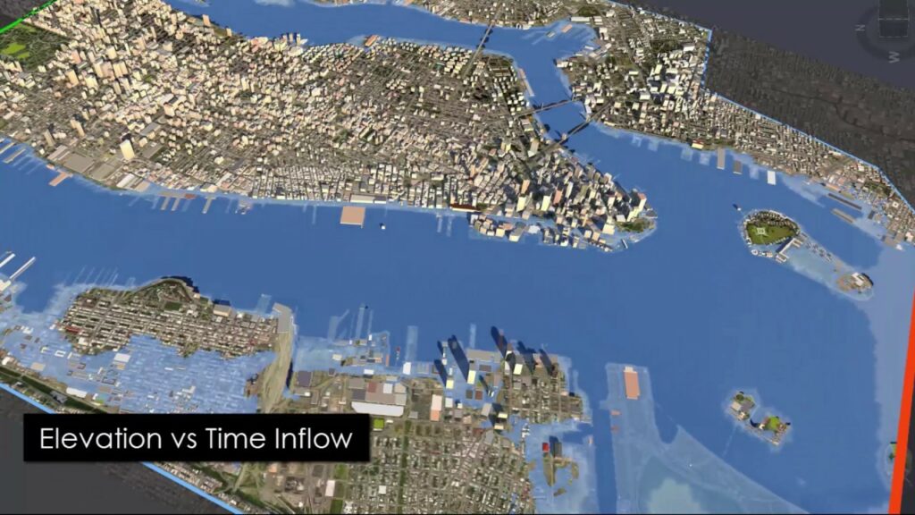
- Simulate flood inundation using InfraWorks’ hydraulic analysis tools, incorporating factors such as terrain elevation, land use, and drainage infrastructure.
- Analyze the extent and depth of flood inundation under various scenarios, including different rainfall intensities, durations, and return periods.
- Evaluate Potential Impacts:
- Evaluate potential impacts of flooding on infrastructure, property, and public safety using InfraWorks’ visualization and reporting tools.
- Identify areas at risk of flooding, including floodplains, low-lying areas, and critical infrastructure, and assess the potential consequences of flooding on community assets and resources.
Designing Drainage Systems in InfraWorks: In addition to analyzing flood risks, InfraWorks provides tools and capabilities for designing drainage systems to mitigate flood impacts. Here’s a detailed guide to designing drainage systems in InfraWorks:
- Define Drainage Basins:
- Define drainage basins and sub-basins within the project area, identifying areas of concentrated rainfall runoff and potential flood risk zones.
- Use InfraWorks’ hydrology tools to delineate drainage basins, calculate drainage area characteristics, and estimate rainfall runoff volumes.
- Design Stormwater Infrastructure:
- Design stormwater infrastructure, including storm drains, culverts, channels, and detention basins, to convey and store excess rainfall runoff.
- Use InfraWorks’ hydraulic analysis tools to size stormwater infrastructure components based on design storm criteria, hydraulic capacity, and performance requirements.
- Optimize Drainage Networks:
- Optimize drainage networks to minimize flood risk and improve stormwater management efficiency.
- Use InfraWorks’ optimization tools to evaluate alternative drainage network configurations, considering factors such as cost, performance, and environmental impact.
- Integrate Green Infrastructure:
- Integrate green infrastructure elements, such as bioswales, rain gardens, and permeable pavements, into the drainage system design to enhance stormwater infiltration and reduce runoff volumes.
- Use InfraWorks’ visualization tools to assess the effectiveness of green infrastructure in mitigating flood risks and improving water quality.
Best Practices for Flood Risk Analysis and Drainage System Design in InfraWorks: In addition to following the step-by-step guidelines outlined above, here are some best practices to optimize flood risk analysis and drainage system design in InfraWorks:
- Validate Data Sources: Validate data sources used for flood risk analysis, including rainfall data, terrain models, and hydrological information, to ensure accuracy and reliability of results.
- Incorporate Climate Change: Incorporate climate change projections into flood risk analysis and drainage system design to account for potential changes in rainfall patterns and flood frequencies over time.
- Engage Stakeholders: Engage with stakeholders, including local authorities, community groups, and regulatory agencies, throughout the flood risk analysis and drainage system design process to gather input, solicit feedback, and ensure alignment with project goals and objectives.
- Iterative Design Process: Adopt an iterative design process for drainage system design, incorporating feedback from stakeholders and conducting multiple iterations to refine and optimize the design over time.
- Consider Resilience Measures: Consider incorporating resilience measures into drainage system design, such as floodproofing, elevation, and floodplain preservation, to enhance the long-term resilience of infrastructure to flooding events.
Conclusion: Analyzing flood risks and designing effective drainage systems are essential steps in ensuring the resilience of infrastructure projects and protecting communities from the impacts of flooding. By following the comprehensive guide outlined above, engineers, planners, and designers can leverage the powerful tools and capabilities of InfraWorks to analyze flood risks, simulate drainage systems, and develop strategies for flood management. With its intuitive modeling, simulation, and visualization tools, InfraWorks empowers users to make informed decisions, optimize designs, and mitigate flood risks effectively, ultimately contributing to the safety, sustainability, and resilience of infrastructure projects and the communities they serve.